


GR 5 - de Dasbourg Pont à Hötel Altitude

collignpn
User GUIDE
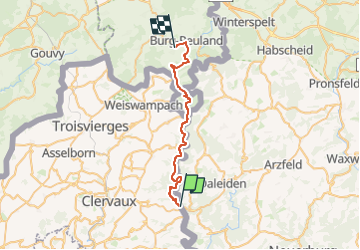

Length
26 km

Max alt
502 m

Uphill gradient
706 m
Km-Effort
35 km

Min alt
277 m

Downhill gradient
583 m
Boucle
No
Creation date :
2024-08-26 12:23:39.689
Updated on :
2024-08-26 12:24:25.728
8h03
Difficulty : Difficult

FREE GPS app for hiking
 SityTrail
IGN / Geographical institutes
SityTrail Plus
The world is yours!
About
Trail On foot of 26 km to be discovered at Unknown, Canton Clervaux, Parc Hosingen. This trail is proposed by collignpn.
Positioning
Country:
Luxembourg
Region :
Unknown
Department/Province :
Canton Clervaux
Municipality :
Parc Hosingen
Location:
Hosingen
Start:(Dec)
Start:(UTM)
294247 ; 5548063 (32U) N.
Comments